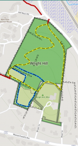
Location: East of Guggins Brook conservation land between Central Street and Massachusetts Avenue (Route 111) in West Acton, and at the top of Wright Terrace.
Loop Trail: 0.5 mile
Acreage: 14.5 acres
Terrain/Trail Conditions: Mostly densely wooded hillside with some open pastures and stone walls at the top of the hill.
Entrances:
- Red trail from Guggins Brook conservation land.
- Red trail entrance from Central Street near the driveway entrance to Half Moon Hill.
- At the top of Wright Hill, near the driveway of 18 Wright Terrace via an easement around that property.
Originally known as Mead Farm, this property is one of the highest points in Acton at 85 meters above sea level. In an outstanding example of Neighborhood Advocacy, the neighbors formed the “Wright Hill Association” to purchase the property with the goal of conserving the open space. Working with Acton Conservation Trust, and the Town of Acton Open Space Committee, a proposal was made to sell the land to the Town using Community Preservation Funds. This proposal was accepted and the resulting Town Meeting article passed unanimously in April 2014.
The main yellow trail begins at an easement adjacent to #18 Wright Terrace at the top of the Wright Terrace. There is no designated parking for this parcel. The pedestrian easement wraps counter clockwise around the private Arts and Crafts style house, along the edge of a farm field, then proceeds north along a stone wall. The trail enters the mixed hardwood forest at a break in the wall and proceeds downhill along an old cart path. At the bottom of the hill and across a private drive, one encounters the trail entrance to Guggins Brook conservation land from Central Street. The Wright Hill yellow trail loops 180 degrees back around and continues to make switchbacks up the hill, and enters a large meadow with an antique corn crib.
There are two 0.25 mile long connecting red trails to Guggins Brook conservation land from Wright Hill conservation land. One is west from the top of Wright Hill, through a stone wall, via a Gregory Lane easement. Alternately, at the bottom of Wright Hill, one may follow along Fort Pond Brook near the driveway entrance to the New View condominiums, adjacent to Central Street. Each of the red trails leading to Guggins is about 0.25 mile long. Looking west from the top of Wright Hill one may view Mount Wachusett, the highest point in Massachusetts east of the Connecticut River.
Volunteers have regular workdays to remove invasive bittersweet and other invasive plants on Wright Hill conservation land. Bluebirds nest in the boxes in the meadows, and many hawks, owls and coyotes hunt for prey in the open grasslands. The occasional apple trees are remnants of the orchards once common throughout Acton.