Location: Northeastern Acton, off Pope Road, toward Concord and Carlisle
Loop trail: 1.3 miles
Acreage: 56
Terrain/Trail Conditions: Level to gently hilly; fairly smooth terrain with a few wet areas
Entrance/Connectors:
- Gravel woods road off westerly side of Pope Road, south of Spencer Brook Road (Parking at parking lot 0.2 mile beyond entrance; Kiosk at parking lot)
- From Spring Hill Conservation Land via red connector trails
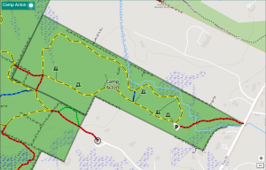
Camp Acton Conservation Land is one of three contiguous conservation lands totaling over 400 acres that form Acton’s largest protected natural area. Each property has its own yellow loop trail, separate entrances, kiosk(s), and parking. Two short red-blazed trails connect the Camp Acton loop trail to the easterly side of the Spring Hill loop trail, which connects in turn to the Nashoba Brook, and Robbins Mill Conservation Lands. It is possible to complete a circuit of nearly 6+ miles through these four properties while crossing through dense woodlands from Pope Road on the east to Route 27 on the west. Besides Camp Acton’s separate map, there is a composite map showing all four parcels. Combined North Acton Trails Map
Camp Acton, which was formerly owned by the Boston Minuteman Boy Scout Council, is the only Acton conservation land able to accommodate individual or group picnicking or overnight camping. Seven relatively level campsites that are stone-free and dry remain from the Boy Scout ownership. Each has space for several tents and is maintained free of poison ivy, brambles, and other undergrowth. Within easy access of the parking area, each site is equipped with a picnic table, a stone campfire ring, and a firewood box and is located in a woodsy setting that allows some privacy. Short paths off an old woods road lead to each site. Permits are required for camping and may be obtained from the Natural Resources Office in the Town Hall or right here. A portable toilet is located in the parking lot, but no water is provided. Close to the parking area is a large fieldstone fireplace, apparently the remains of an earlier structure. However, it is not suitable for any type of fire in its current condition.
Just beyond the gate at the parking lot, the yellow loop trail begins. Going clockwise around the loop, the trail proceeds via a continuation of the red access woods road from the Pope Road entrance through an impressive grove of 100-year-old white pines. One of the larger campsites (number 1 on the map) is situated on a knoll to the east of this woods road not far from the parking area. The grove’s high canopy filters the light that reaches the brushed-out ground beneath. A crop of young pine seedlings flourishes here and creates an effect of light, feathery growth beneath the towering canopy. Surrounding the grove, pines are mixed with hardwoods, including oak, white birch, maple, and several large yellow birches.
The original woods road, dating from the Boy Scout occupancy, proceeds in a northwesterly direction for approximately half the distance to the property’s boundary with Spring Hill Conservation Land. This road gradually narrows to a footpath. A short distance beyond the last campsite (number 7), the two red connector trails from the Spring Hill loop trail join Camp Acton from the south and west. At this intersection, the Camp Acton loop trail jogs briefly to the north and then heads eastward, roughly paralleling the woods road as it returns to the parking lot. Along this easterly section of the loop trail, the walker may enjoy several different habitats, including wetlands and a small stream.
Along the northerly boundary, extensive wetlands (comprising about 20 percent of the total acreage) support mature vegetation typical of such areas, red maple being the predominant species. Flowing out of the wetlands is a picturesque little stream, unnamed, which cascades over low rocky drops for a short distance directly alongside the yellow trail and then flows under the access road before eventually joining Spencer Brook. In the property’s southeasterly corner, the loop trail passes by the base of a small moss- and fern-covered rocky outcrop. The Camp Acton property has an isolated vernal pool along its southern boundary, just west of campsite number 2.